© 2024 YAW.NEWS
  Sign In   Register
Details
Aircraft Takeoff Weight Approx. 377 g Dimensions 185×212×64 mm (L×W×H) Max Ascent Speed ...
Aircraft

Takeoff Weight
Approx. 377 g

Dimensions
185×212×64 mm (L×W×H)

Max Ascent Speed
‌6 m/s (Normal mode)
9 m/s (Sport mode)

Max Descent Speed
‌6 m/s (Normal mode)
9 m/s (Sport mode)

Max Horizontal Speed
(near sea level, no wind)
8 m/s (Normal mode)
‌16 m/s (Sport mode)
27 m/s (Manual mode)*

* No faster than 19 m/s with the Manual mode in the EU regions.

Max Takeoff Altitude
5000 m

Measured in a windless environment when taking off from an altitude of 5000 m and ascending vertically by 500 m, using Sport mode, and from 100% battery level until 20%. Data is for reference only. Always pay attention to reminders on the goggles' screens during your flight.

Max Flight Time
‌Approx. 23 mins

‌Measured when flying forward at a speed of 21.6 kph in a windless environment at sea level, with camera parameters set to 1080p/30fps, video mode off, and from 100% battery level until 0%. Data is for reference only. Always pay attention to reminders on the goggles' screens during your flight.

Max Hovering Time
‌Approx. 21 mins

‌‌Measured when hovering in a windless environment at sea level, with camera parameters set to 1080p/30fps, video mode off, and from 100% battery level until 0%. Data is for reference only. Always pay attention to reminders on the goggles' screens during your flight.‌

Max Flight Distance
13.0 km‌

‌Measured when flying forward at a speed of 43.2 kph in a windless environment at sea level, with camera parameters set to 1080p/30fps, video mode off, and from 100% battery level until 0%. Data is for reference only. Always pay attention to reminders on the goggles' screens during your flight.

Max Wind Speed Resistance
10.7 m/s (Level 5)

Operating Temperature
-10° to 40° C (14° to 104° F)

Global Navigation Satellite System
GPS + Galileo + BeiDou

Hovering accuracy range
Vertical:
±0.1 m (with vision positioning)
±0.5 m (with GNSS positioning)

Horizontal:
±0.3 m (with vision positioning)
±1.5 m (with GNSS positioning)

Internal Storage
46 GB

Class
C1 (EU)

Camera

Image Sensor
‌1/1.3-inch image sensor
Effective Pixels: 12 MP

Lens
‌FOV: 155°
Format Equivalent: 12 mm
Aperture: f/2.8
Focus: 0.6 m to ∞

ISO Range
100-25600 (Auto)
100-25600 (Manual)

Shutter Speed
Video: 1/8000-1/30 s
Photo: 1/8000-1/50 s

Max Image Size
4000×2256 (16∶9)
4000×3000 (4∶3)

Still Photography Mode
Single shot

Photo Format
JPEG

Video Resolution
4K (4∶3): 3840×2880@30/50/60fps
4K (16∶9): 3840×2160@30/50/60/100fps
2.7K (4∶3): 2688×2016@30/50/60fps
2.7K (16∶9): 2688×1512@30/50/120fps
1080p (4∶3): 1440×1080@30/50/120fps
1080p (16∶9): 1920×1080@30/50/120fps

Video Format
MP4 (H.264/H.265)

Max Video Bitrate
130 Mbps

Supported File System
exFAT

Color Mode
Standard
D-Log M

Camera FOV
Supports normal mode, wide-angle mode, and ultra-wide-angle mode.

EIS
Supports RockSteady 3.0+ and HorizonSteady
Can be disabled*

* When stabilization is turned off, footage captured with the wide-angle view supports offline stabilization Gyroflow.

Gimbal

Stabilization
Single-axis mechanical gimbal (tilt)

Mechanical Range
Tilt: -95° to 90°

Controllable Range
Tilt: -85° to 80°

Max Control Speed (tilt)
100°/s

Angular Vibration Range
±0.01°

Electronic Roll Axis
Real-time screen correction is unavailable during recording, but can be applied to the footage recorded on the drone.

Sensing

Sensing Type
Downward and backward visual positioning

Downward
ToF Effective Measurement Height: 10 m
Precise Hovering Range: 0.3-10 m
Measurement Range: 0.3-20 m
FOV: Horizontal 78°, Vertical 78°

Backward
Measurement Range: 0.5-20 m
FOV: Horizontal 78°, Vertical 78°

Operating Environment
Diffuse reflective surfaces with discernible patterns, diffuse reflectivity > 20% (such as concrete pavement)
Adequate lighting (lux > 15, normal indoor lighting conditions)

Video Transmission

Video Transmission System
O4

Live View Quality
1080p@30/50/60/100fps

Operating Frequency
2.400-2.4835 GHz
5.170-5.250 GHz*
5.725-5.850 GHz*

* 5.170-5.250 GHz and 5.725-5.850 GHz can be used only in countries and regions where permitted by local laws and regulations.

Transmitter Power (EIRP)
2.4 GHz:
<33 dBm (FCC)
<20 dBm (CE/SRRC/MIC)

5.1 GHz:
More
People Who Liked This
No users available
Recent Photos
Link copied to your clipboard
Filter Timeline:
Pinned Items
Recent Activities
  • DJI AVATA has been created

    DJI AVATA

    Aircraft

    Takeoff Weight
    Approx. 377 g

    Dimensions
    185×212×64 mm (L×W×H)

    Max Ascent Speed
    ‌6 m/s (Normal mode)
    9 m/s (Sport mode)

    Max Descent Speed
    ‌6 m/s (Normal mode)
    9 m/s (Sport mode)

    Max Horizontal Speed
    (near sea level, no...
    Aircraft

    Takeoff Weight
    Approx. 377 g

    Dimensions
    185×212×64 mm (L×W×H)

    Max Ascent Speed
    ‌6 m/s (Normal mode)
    9 m/s (Sport mode)

    Max Descent Speed
    ‌6 m/s (Normal mode)
    9 m/s (Sport mode)

    Max Horizontal Speed
    (near sea level, no wind)
    8 m/s (Normal mode)
    ‌16 m/s (Sport mode)
    27 m/s (Manual mode)*

    * No faster than 19 m/s with the Manual mode in the EU regions.

    Max Takeoff Altitude
    5000 m

    Measured in a windless environment when taking off from an altitude of 5000 m and ascending vertically by 500 m, using Sport mode, and from 100% battery level until 20%. Data is for reference only. Always pay attention to reminders on the goggles' screens during your flight.

    Max Flight Time
    ‌Approx. 23 mins

    ‌Measured when flying forward at a speed of 21.6 kph in a windless environment at sea level, with camera parameters set to 1080p/30fps, video mode off, and from 100% battery level until 0%. Data is for reference only. Always pay attention to reminders on the goggles' screens during your flight.

    Max Hovering Time
    ‌Approx. 21 mins

    ‌‌Measured when hovering in a windless environment at sea level, with camera parameters set to 1080p/30fps, video mode off, and from 100% battery level until 0%. Data is for reference only. Always pay attention to reminders on the goggles' screens during your flight.‌

    Max Flight Distance
    13.0 km‌

    ‌Measured when flying forward at a speed of 43.2 kph in a windless environment at sea level, with camera parameters set to 1080p/30fps, video mode off, and from 100% battery level until 0%. Data is for reference only. Always pay attention to reminders on the goggles' screens during your flight.

    Max Wind Speed Resistance
    10.7 m/s (Level 5)

    Operating Temperature
    -10° to 40° C (14° to 104° F)

    Global Navigation Satellite System
    GPS + Galileo + BeiDou

    Hovering accuracy range
    Vertical:
    ±0.1 m (with vision positioning)
    ±0.5 m (with GNSS positioning)

    Horizontal:
    ±0.3 m (with vision positioning)
    ±1.5 m (with GNSS positioning)

    Internal Storage
    46 GB

    Class
    C1 (EU)

    Camera

    Image Sensor
    ‌1/1.3-inch image sensor
    Effective Pixels: 12 MP

    Lens
    ‌FOV: 155°
    Format Equivalent: 12 mm
    Aperture: f/2.8
    Focus: 0.6 m to ∞

    ISO Range
    100-25600 (Auto)
    100-25600 (Manual)

    Shutter Speed
    Video: 1/8000-1/30 s
    Photo: 1/8000-1/50 s

    Max Image Size
    4000×2256 (16∶9)
    4000×3000 (4∶3)

    Still Photography Mode
    Single shot

    Photo Format
    JPEG

    Video Resolution
    4K (4∶3): 3840×2880@30/50/60fps
    4K (16∶9): 3840×2160@30/50/60/100fps
    2.7K (4∶3): 2688×2016@30/50/60fps
    2.7K (16∶9): 2688×1512@30/50/120fps
    1080p (4∶3): 1440×1080@30/50/120fps
    1080p (16∶9): 1920×1080@30/50/120fps

    Video Format
    MP4 (H.264/H.265)

    Max Video Bitrate
    130 Mbps

    Supported File System
    exFAT

    Color Mode
    Standard
    D-Log M

    Camera FOV
    Supports normal mode, wide-angle mode, and ultra-wide-angle mode.

    EIS
    Supports RockSteady 3.0+ and HorizonSteady
    Can be disabled*

    * When stabilization is turned off, footage captured with the wide-angle view supports offline stabilization Gyroflow.

    Gimbal

    Stabilization
    Single-axis mechanical gimbal (tilt)

    Mechanical Range
    Tilt: -95° to 90°

    Controllable Range
    Tilt: -85° to 80°

    Max Control Speed (tilt)
    100°/s

    Angular Vibration Range
    ±0.01°

    Electronic Roll Axis
    Real-time screen correction is unavailable during recording, but can be applied to the footage recorded on the drone.

    Sensing

    Sensing Type
    Downward and backward visual positioning

    Downward
    ToF Effective Measurement Height: 10 m
    Precise Hovering Range: 0.3-10 m
    Measurement Range: 0.3-20 m
    FOV: Horizontal 78°, Vertical 78°

    Backward
    Measurement Range: 0.5-20 m
    FOV: Horizontal 78°, Vertical 78°

    Operating Environment
    Diffuse reflective surfaces with discernible patterns, diffuse reflectivity > 20% (such as concrete pavement)
    Adequate lighting (lux > 15, normal indoor lighting conditions)

    Video Transmission

    Video Transmission System
    O4

    Live View Quality
    1080p@30/50/60/100fps

    Operating Frequency
    2.400-2.4835 GHz
    5.170-5.250 GHz*
    5.725-5.850 GHz*

    * 5.170-5.250 GHz and 5.725-5.850 GHz can be used only in countries and regions where permitted by local laws and regulations.

    Transmitter Power (EIRP)
    2.4 GHz:
    <33 dBm (FCC)
    <20 dBm (CE/SRRC/MIC)

    5.1 GHz:
    More
    0
    0
    0
    0
    0
    0
    Comments (0)
    Post is under moderation
    Stream item published successfully. Item will now be visible on your stream.
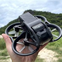
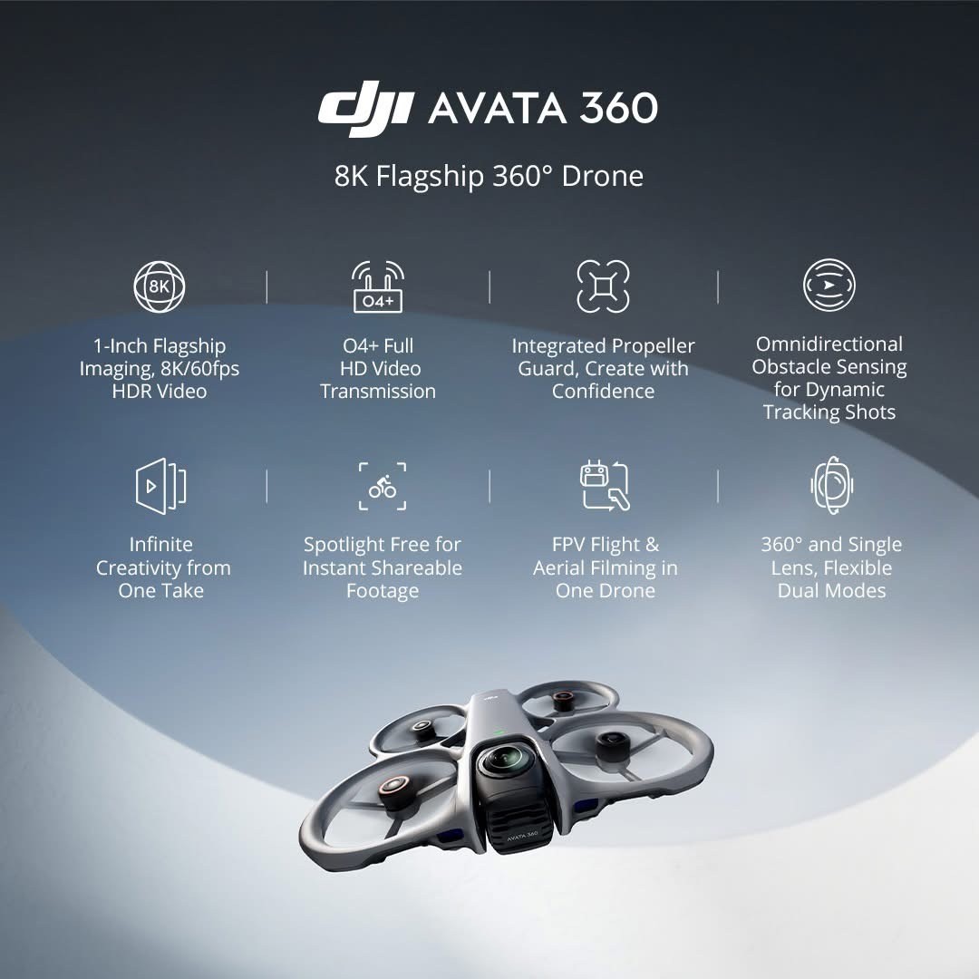
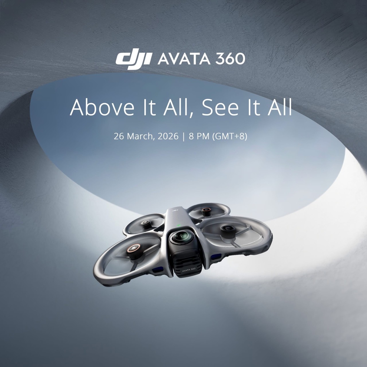
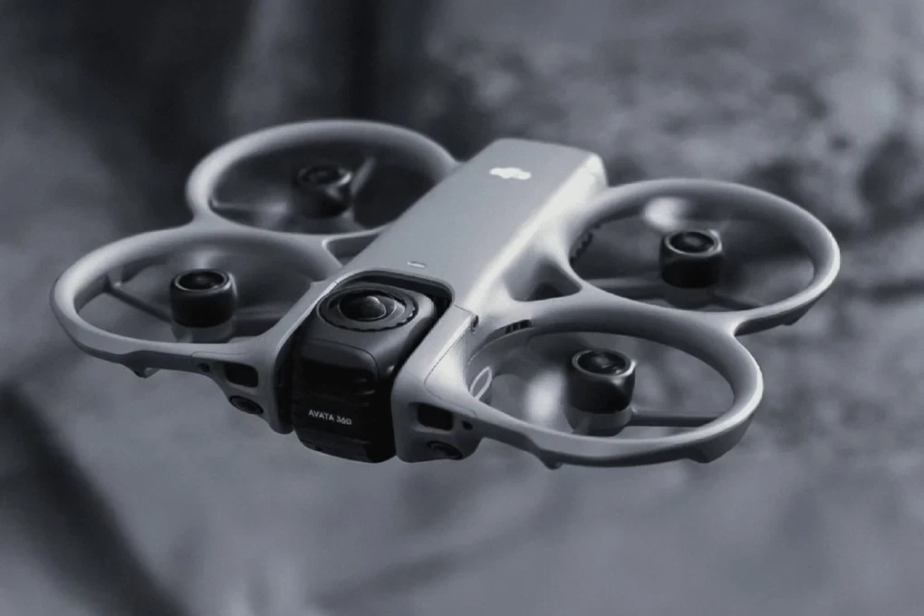
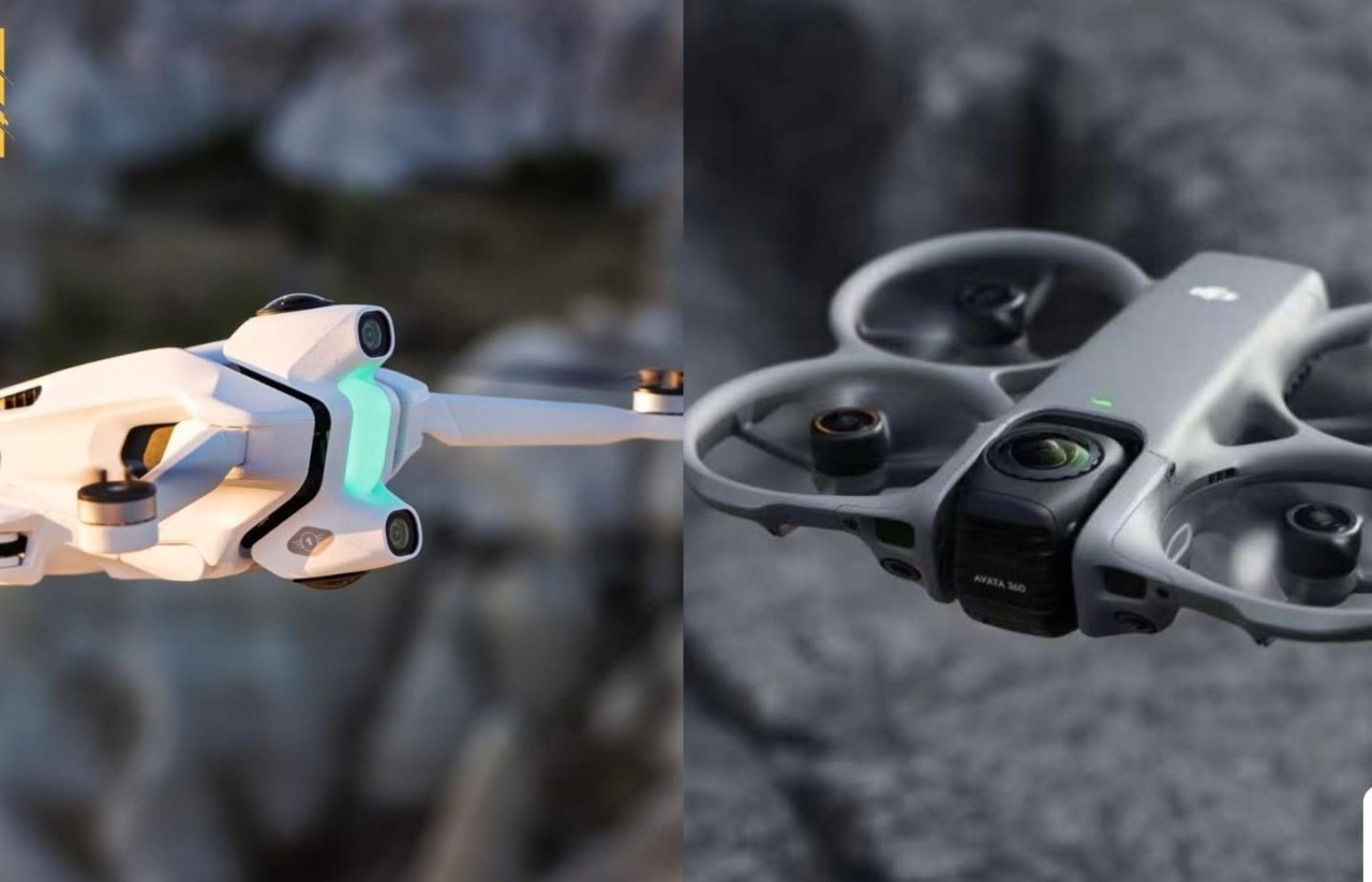
There are no activities here yet
Unable to load tooltip content.